Share Wianamatta South Creek flood study on FacebookShare Wianamatta South Creek flood study on X (formerly Twitter)Share Wianamatta South Creek flood study on LinkedinEmail Wianamatta South Creek flood study link
The Wianamatta South Creek flood study consultation has now closed.
Why this study is important
Council has a duty of care to manage lands subject to flooding within our Local Government Area. This duty is established by the NSW Government's Flood Prone Land Policy, in the NSW Government's Flood Risk Management Manual. The policy outlines the flood risk management processes by which councils should operate to reduce the risk to life, property and other impacts from flooding.
One of our obligations under this policy is to keep the information relating to flooding within Blacktown City up to date. This includes our flood maps and our planning (Section 10.7) certificates for each property. As part of our commitment to this obligation, we have recently completed the Wianamatta South Creek flood study. The report can be downloaded and viewed here.
Next steps
An assessment of feedback received from this process will be reported to Council, which will then decide whether to adopt the study. If the study is adopted:
we will update our maps and databases to reflect the most recent flooding information
we will prepare a Floodplain risk management study and plan for Wianamatta South Creek, subject to funding being available.
Where you can find out more
If you have any questions about the study, please see the Frequently Asked Questions on this page, or contact our Floodplain and Stormwater team at floodfeedback@blacktown.nsw.gov.au or on 02 5300 6000.
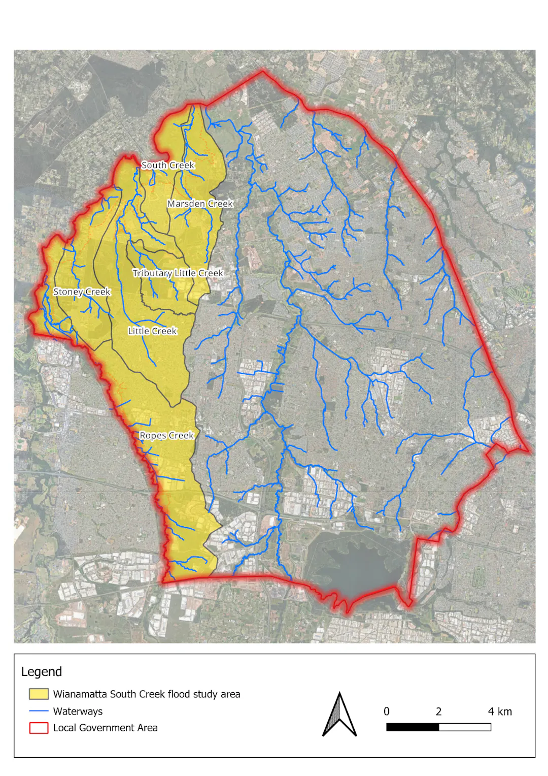
You can view the Wianamatta South Creek flood study maps below. Or click here to open a new tab.
The Wianamatta South Creek flood study consultation has now closed.
Why this study is important
Council has a duty of care to manage lands subject to flooding within our Local Government Area. This duty is established by the NSW Government's Flood Prone Land Policy, in the NSW Government's Flood Risk Management Manual. The policy outlines the flood risk management processes by which councils should operate to reduce the risk to life, property and other impacts from flooding.
One of our obligations under this policy is to keep the information relating to flooding within Blacktown City up to date. This includes our flood maps and our planning (Section 10.7) certificates for each property. As part of our commitment to this obligation, we have recently completed the Wianamatta South Creek flood study. The report can be downloaded and viewed here.
Next steps
An assessment of feedback received from this process will be reported to Council, which will then decide whether to adopt the study. If the study is adopted:
we will update our maps and databases to reflect the most recent flooding information
we will prepare a Floodplain risk management study and plan for Wianamatta South Creek, subject to funding being available.
Where you can find out more
If you have any questions about the study, please see the Frequently Asked Questions on this page, or contact our Floodplain and Stormwater team at floodfeedback@blacktown.nsw.gov.au or on 02 5300 6000.
You can view the Wianamatta South Creek flood study maps below. Or click here to open a new tab.


Introductory Video Presentation